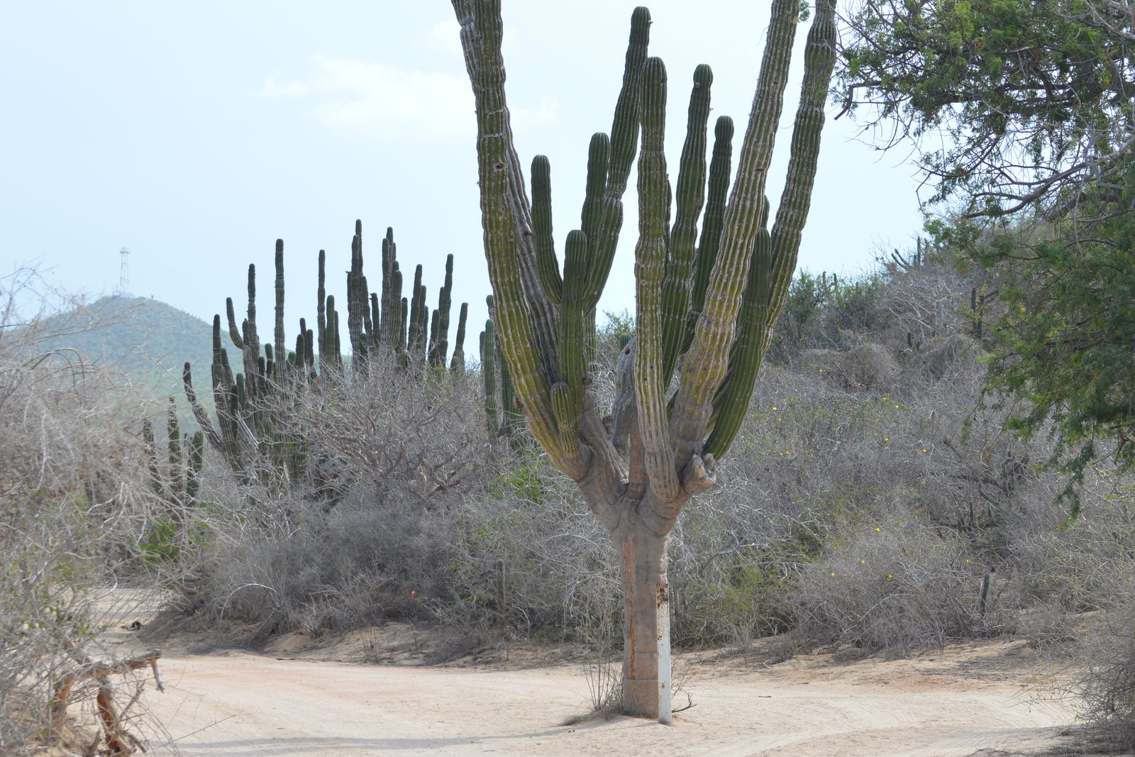
Most first-time visitors come to Cabo expecting beach time, sportfishing, and dinner reservations. What they don’t expect is to spend a morning scrambling through a desert canyon with cardón cacti towering around them, or to look down on the Pacific from a ridge in the Sierra de la Laguna with no other hikers in sight. But Los Cabos has genuine hiking territory, from easy canyon walks accessible on a half-day from the marina to multi-day mountain routes that feel nothing like the resort corridor.
This guide covers the main hiking areas, what each one genuinely involves, how to get there, and what to bring.
The Landscape You’re Working With
The Baja California peninsula is not the terrain most people picture when they think Mexico. There are no jungle trails here. What you get instead is Sonoran Desert: cardón cacti that reach 60 to 70 feet tall, brittle brush, palo verde trees, and dry arroyos that funnel rainfall once or twice a year. It’s dramatic terrain to walk through, but the heat is not optional.
The Sierra de la Laguna, a granite mountain range running down the spine of Baja California Sur, is the main hiking destination in the region. At its highest point, Cerro de la Laguna at roughly 6,600 feet, the desert gives way to pine and oak forest. The transition happens fast and feels genuinely surprising. The range is protected as a UNESCO Biosphere Reserve, which limits development but keeps the trails open.
Closer to Cabo San Lucas, the canyons and arroyos around the Corridor between the two towns offer shorter, more accessible options. Wild Canyon Adventures, a commercial outdoor park about 25 minutes east of the marina, has built infrastructure around some of this landscape.
Wild Canyon Adventures
If you want a structured outdoor experience with a hiking component and prefer not to rent a car or hire a separate guide, Wild Canyon Adventures is the most accessible option for visitors based in the marina area. It sits in the El Tule Canyon zone, between Cabo San Lucas and San José del Cabo along the Corridor.
The activity menu includes zip-lines, a bungee swing, and a guided camel tour through the canyon floor, but the hiking component runs through genuine desert terrain with canyon walls and cactus at close range. You’re walking on rocky arroyo beds, which makes for more interesting footing than a paved path. The hiking portions run 1 to 2 hours depending on which package you book.
Combo tickets typically run $60 to $90 USD per person. Shared transportation from the marina area adds about $15 to $20 USD round-trip. Book early in your trip rather than as a last-minute option: popular dates, especially in January through March, sell out a week or more ahead. This is also a good pairing with an ATV or off-road adventure if you want a full day of desert activity.
Mornings are better than afternoons in the canyon from October through April. Afternoon winds can pick up, and the canyon walls offer less shade once the sun moves past midday.
Sierra de la Laguna Biosphere Reserve
The Sierra de la Laguna is the most serious hiking destination in Baja California Sur. The full traverse, crossing the range from the Pacific side near Todos Santos to the Sea of Cortez side, takes three to four days and requires camping gear, water filtration, and some navigation experience. For day hikers or overnight trekkers who want a taste of the mountains without the full traverse, shorter entry routes work well.
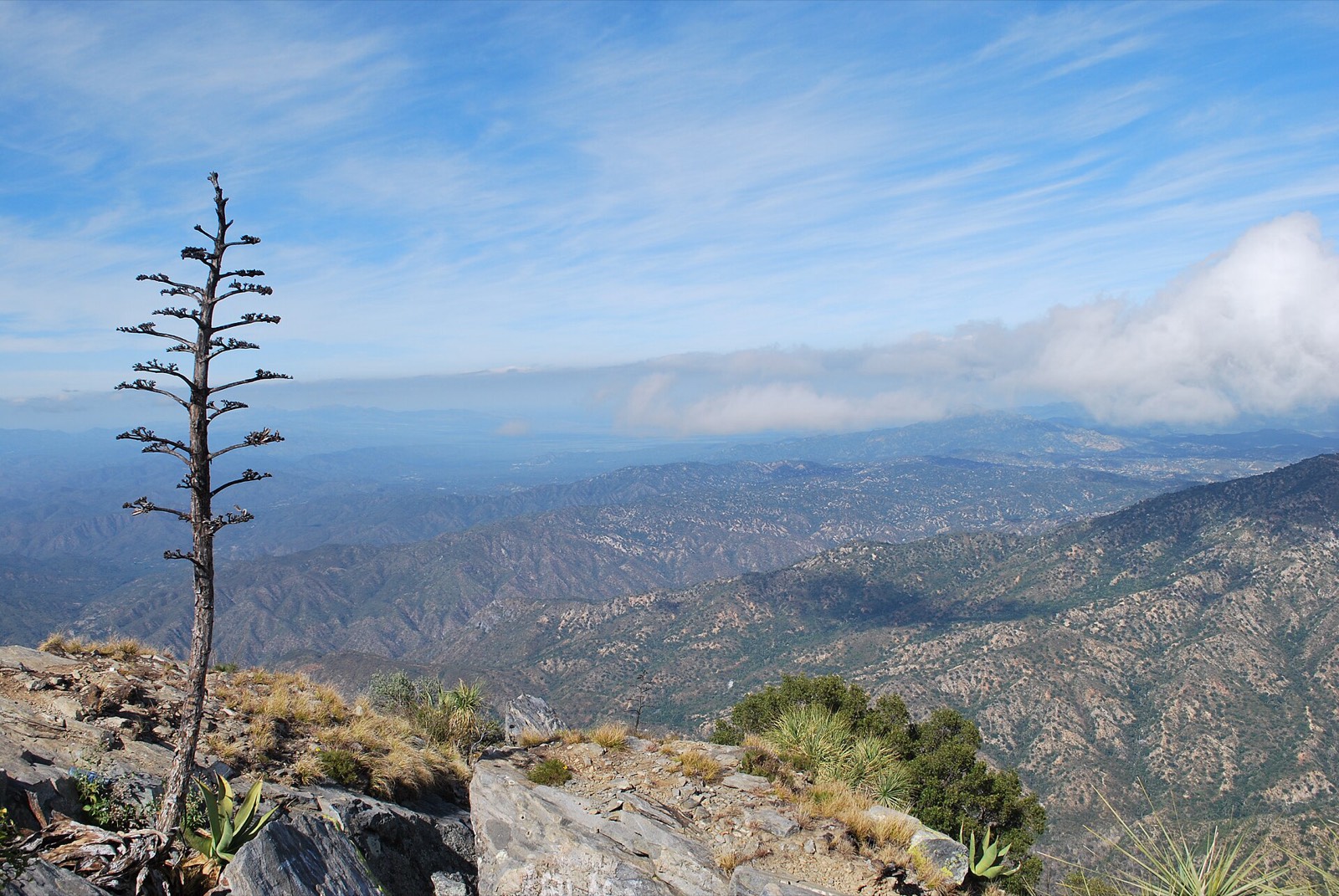
The most common access point for visitors based in Cabo is the La Burrera trailhead, starting near the small town of Santiago. Santiago sits about 90 minutes north of San José del Cabo on Mexico 1. From La Burrera, you can hike into the canyon and up toward the pine forest zone in a long day (roughly 8 to 10 miles round-trip with about 2,500 feet of elevation gain). This is genuine backcountry: no facilities, no cell service, and the trail is not consistently marked.
The Todos Santos side of the Sierra offers gentler access to the lower pine zone and pairs well with a day trip into town. The drive from Cabo San Lucas to Todos Santos takes about 75 minutes on Mexico 19.
Temperatures in the high Sierra run 15 to 20 degrees Fahrenheit cooler than the coast. If you’re hiking in December or January, bring a layer. Water sources exist in the canyons but should be filtered. The reserve has no permit system, but Leave No Trace standards apply: pack out everything you carry in, stay on existing tracks, and don’t camp in the streambed.
El Triunfo and the Mine Trail
El Triunfo is a small ghost town in the Sierra de la Laguna foothills, about 67 kilometers north of San José del Cabo. In the 1800s it was one of the most populous towns in Baja California Sur, a silver and gold mining center with a population in the thousands. The mines closed in the early 20th century. What’s left is a compact cluster of colonial buildings, a chimney from the ore-processing plant, several artisan workshops that attract day-trippers from La Paz, and a cafe that’s earned a reputation well beyond its location.
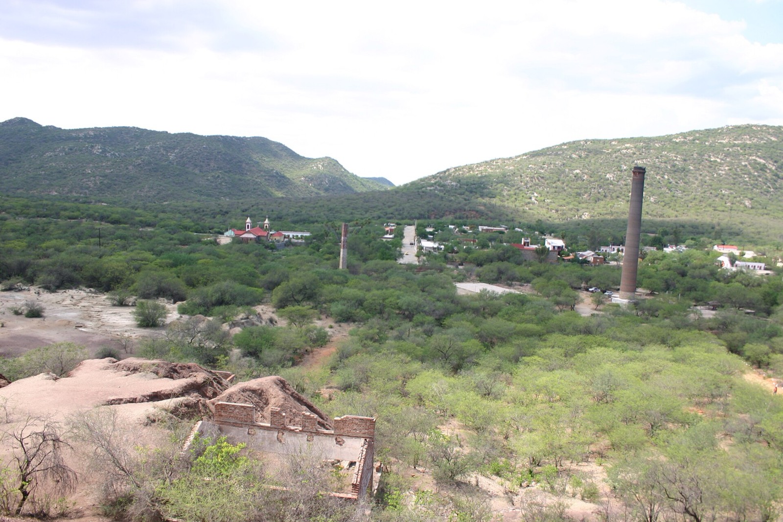
Getting there requires driving north on Mexico 1 toward La Paz, then turning west onto a dirt road that winds into the foothills. A high-clearance vehicle is not strictly required, but the road is unpaved and can be rough after rain. Plan 90 to 100 minutes each way from San José del Cabo.
Hiking around El Triunfo is informal and self-guided. Old mining roads lead into the surrounding hills, with views back toward the desert flats and, on clear days, toward the coast. There are no marked trailheads. Download offline GPS tracks before you leave cell range. The terrain is open and rocky, with cardón, palo blanco, and thorny scrub framing the route. Most visitors spend 2 to 3 hours hiking before heading back into town.
The Cafetera El Triunfo, inside a restored colonial building on the main plaza, is worth building into your stop. El Triunfo works well as a full-day trip from either Cabo San Lucas or the East Cape road.
Corridor Canyon Walks and the Arroyo San José
Several canyon routes cut through the Corridor zone between the two towns. These are not maintained trails but are walkable desert terrain worth knowing about, especially for travelers who want a morning outside without committing to a full guided tour.
The arroyos that cross Mexico 1 between Cabo San Lucas and San José del Cabo all lead inland toward the foothills, and most are passable on foot for several miles before the brush thickens or the elevation gain becomes steep. They’re best explored with a downloaded offline map and a reliable water supply.
The Arroyo San José runs behind San José’s art district, starting near the town estuary. It’s a flat, easy walk through riparian vegetation and into the lower desert, with good birdwatching in early morning. The estuary is a year-round habitat for herons, egrets, and migratory shorebirds. This route requires no car and no guide: you can start from the art district on foot and turn around whenever you want.
Heading east from San José toward the East Cape opens up increasingly remote terrain. The East Cape road from Los Barriles toward Cabo Pulmo passes through canyon systems where informal pull-offs let you walk into the hills for an hour or two. Most visitors drive this route to reach the reef at Cabo Pulmo, but the canyon terrain on the way is worth a stop.
Guided Tours vs. Going on Your Own
For the Sierra de la Laguna and El Triunfo, a local guide is worth the cost if this is your first visit. The trails aren’t consistently marked, navigation requires some experience, and the heat risk in shoulder-season months is real. Several tour operators based in San José del Cabo run guided day hikes and overnight trips into the Sierra. Expect to pay $80 to $150 USD per person for a guided day hike that includes transportation, water, and snacks.
For Wild Canyon Adventures and the arroyo walks near San José, you can go independently without meaningful risk. Bring more water than you think you’ll need (at minimum 1 liter per hour of hiking), sun protection, and a charged phone with offline maps downloaded ahead of time.
If you’re building a trip around outdoor activities, the site’s adventure itinerary covers a seven-day plan that weaves in the Sierra, the East Cape, and water-based activities on the Sea of Cortez. For a guided desert experience at a gentler pace, camel and desert tours cover some of the same terrain through the canyon zone near the Corridor.
When to Go and What to Bring
Hiking season in Los Cabos runs from late October through early April. Outside that window, the combination of heat and humidity makes anything beyond a short early-morning walk genuinely risky. In August and September, temperatures in the canyons regularly exceed 100°F, and flash flood risk from late-season Pacific storms is real.
November through February is the best window: daytime highs on the coast run 75 to 83°F, and the foothills and Sierra are 10 to 15 degrees cooler. March and April work well for most routes. October is transitional; conditions are improving, but some canyon trails may still have muddy sections from the hurricane season. The best time to visit Los Cabos page has a full month-by-month breakdown covering weather, crowds, and activity windows.
Pack list for a half-day hike:
- Water: at minimum 1 liter per hour of hiking. More than you think you need.
- Sun protection: broad-brim hat, SPF 50+ sunscreen, UV-protection sleeves if you burn easily.
- Footwear: trail runners or light hiking boots. Sandals are a bad idea in cactus terrain.
- Snacks: high-energy food you can eat on the move.
- Offline maps: download your route in Gaia GPS or Maps.me before leaving cell range.
- Emergency layer: a windbreaker for the Sierra in winter months.
- Small first-aid kit: bandages, blister treatment, ibuprofen.
The official Los Cabos tourism website (visitloscabos.travel) publishes trail condition updates for the Sierra de la Laguna area and notes any closures following major storms.
Where to Base Yourself
San José del Cabo gives better access to hiking territory than Cabo San Lucas. It sits closer to the Sierra trailheads, the El Triunfo road, and the East Cape. Small hotels in the art district put you within walking distance of the Arroyo San José route. For a full look at where to base your trip, the where to stay by area guide covers the tradeoffs between the marina district, the Corridor resorts, and San José.